Flood Watch in effect for Atascadero and San Luis Obispo County from 3 p.m. Wednesday to 6 a.m. Thursday

Rain rates of up to 1 inch per hour possible, especially in the mountains
– A Flood Watch is in effect for all of San Luis Obispo County from 3 p.m. Wednesday, Nov. 18, to 6 a.m. Thursday, Nov. 19, the National Weather Service in Los Angeles/Oxnard said in an update issued at 3:46 p.m. Tuesday.
The watch covers the county’s beaches, inland Central Coast, Santa Lucia Mountains, Southern Salinas Valley, interior valleys and mountains, including Atascadero, Paso Robles, Templeton, San Miguel, Shandon, Creston, Cambria, Morro Bay and San Luis Obispo.
Flooding caused by excessive rainfall remains possible, the weather service said. Excessive rainfall may result in significant flooding of roads and other low-lying areas, heavy flows in creeks and canyons, and rockslides, mudslides and debris flows in recent burn scars.
Rain rates of up to 1 inch per hour are expected, especially in the mountains. An earlier version of the watch, issued at 12:14 p.m. Tuesday, said rates of up to 1 inch per hour were expected in the mountains and up to three-quarters of an inch per hour elsewhere. Residents should monitor later forecasts and be alert for possible Flood Warnings. Those living in areas prone to flooding should be prepared to take action if flooding develops, the weather service said.
The weather service’s area forecast discussion said rain could arrive in San Luis Obispo County as early as Wednesday morning, with heavier rates after 10 p.m. Wednesday along the county coast, and that strong winds of 30 to 45 mph may accompany the storm Wednesday night and Thursday.
A High Surf Advisory remains in effect for San Luis Obispo County beaches until 9 p.m. Friday, and a Coastal Flood Advisory is in effect from 3 to 10 a.m. Thursday, according to a coastal hazard message issued at 2:15 p.m. Tuesday. The weather service forecast large breaking waves of 10 to 19 feet, with local sets of 20 to 22 feet, peaking from late Wednesday through Thursday night, along with dangerous rip currents and minor coastal flooding. Moderate flooding of seawater is likely over some vulnerable low-lying coastal areas around high tide, including beach parking lots, bike paths and harbor walkways, with moderate to significant beach erosion possible and isolated damage unlikely but possible, especially to the Pismo and Cayucos piers.
Weather Underground’s forecast for Atascadero shows 2.87 inches of rain today, Wednesday, Nov. 18, with a high near 60 and a low near 50. A Wind Advisory is in effect from 2 p.m. Wednesday to 7 a.m. Thursday. Rain and wind continue Thursday morning, Nov. 19, with about 0.31 inch, before skies clear Friday and Saturday. Showers return Sunday, Nov. 22, with about 0.15 inch, followed by rain Tuesday, Nov. 24, with about 0.5 inch, and showers Wednesday, Nov. 25, with another 0.44 inch.
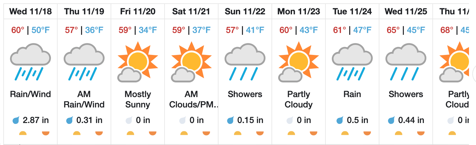
For a 10-day forecast, visit the Weather Underground forecast for Atascadero.